
This chapter is primarily about our camping trip to Utah and the Grand Canyon but I want to take a moment to say goodbye to my very special companion (not “just a dog”) Jarvis who died just before we left. As I write this it is the Feast of St Francis when it is common in Episcopal communities to invite pets to church to be blessed. The last time Jarvis attended this special service, I was singing in the choir where he sat very attentively on a chair next to me and didn’t make a sound. When we went to the front for his blessing he sat and listened to the priest as if this were something he did every Sunday. Today only his photo and collar were present in the church but I really feel that he continues to wait for me when my turn comes to join him and once again he will dance a happy dance and let me know that he is happy I am home. (A narrative that Jarvis wrote about his life as a boat dog a few years back: https://ncgregory.larper.com/Chapter-Pages/Chapter%206%20Jarvis.pdf )


In the way of some background, Clarice has wanted to revisit
some of the places we travelled to with our children many years ago but our
spring trip is usually too early as there is still snow on the ground and
summer trips are out of the question with temperatures in the 100s. After confirming with a friend who is a Utah
resident that September – October should be a great time to visit weather wise
we headed out in our Airstream trailer. This has been a trip of serendipity
with many of the things we have found to wow us being totally unexpected.

Our first stop was at what was advertised as an alpaca farm
in Eastern Oregon. Instead we found a
woman who raises very small cattle, very small horses, goats, AND alpacas. She is trying to build her income from
attracting HarvestHosts guests so they will purchase the alpaca items many of
which come from Peru (we both ended up with hiking socks). Her eagerness to tell all about her animals
was really the fun part of the stop (she reminded us of the woman who hired our
son Bryan when he was young to muck calf pens who talked a mile-a-minute and
was as bright as he was so the two of them really hit it off).
Next the map said we should plan to stop near Boise, Idaho
but I really didn’t want to drive through town so we took a scenic byway next
to the Snake River Birds of Prey National Conservation Area. We ended up camping in an open area overlooking
the canyon of the Snake River. What we
didn’t realize was we were camped in the takeoff and landing zone of some local
kite gliders. They politely alerted us
that we would soon see about 7 kiters come and use the open area along with us
for the evening which was really quite fun to watch.


A bit about POTA (Parks on the Air) which is a part of the
amateur radio (AKA: ham radio) hobby where ham operators (me in this case) will
set up a temporary station at a government park or on government land and try
to make contacts with other ham operators.
If you get 10 or more contacts in your logbook you have successfully
“activated” the park. Since our trailer
is set up as a mobile radio station I often try to activate a park when we stay
there. In the case of Birds of Prey I
was able to make 11 contacts so a successful activation. Other times due to much more powerful
transmitters booming in, or the ionosphere not being active, or my antenna
glitching, or, or, or my attempts end up in frustration.

Our next serendipitous stop was at Antelope Island State
Park in (literally) the Great Salt Lake of Utah. Looking at the website the photos left me
with the impression that the island was just a big grassland with some imported
bison but it was a spot where we could reserve a camping site for a couple of
nights outside of Salt Lake City during the weekend (we avoid trying to find
first-come sites on Friday through Sunday morning as those are the times when
campgrounds tend to fill quickly). What
we found was a very interesting and scenic island where there is a very large
bison herd (they cull it to about 300 animals to make sure the island can
support the numbers as well as the native animals such as antelope). We kept ourselves very busy riding our
e-bikes around the island, hiking on trails, driving to the other end of the
island, taking photos of scenery bison and flowers, and doing my POTA hobby
(another successful activation!).


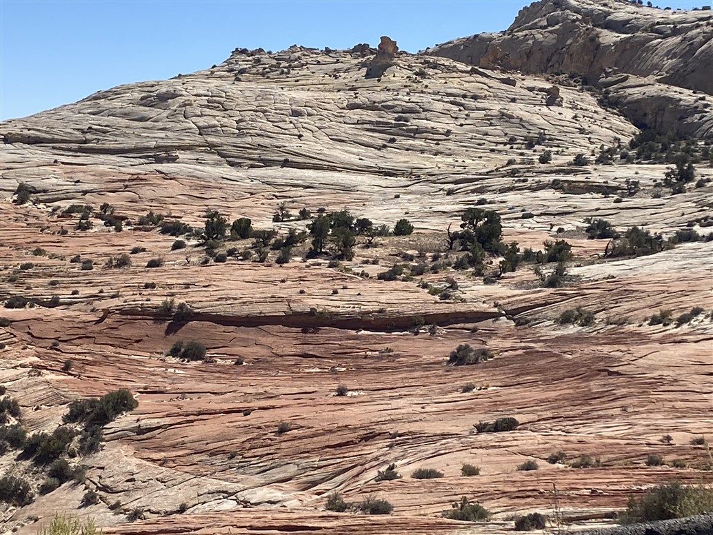
We kept reading about the San Rafael Swell as we looked for
our next place to stay. We had no idea
what this meant but there was reported to be legal dispersed camping so we
headed down a dirt road in good condition and serendipity struck again. The San Rafael Swell is a huge uplift area
cut into by the Buckhorn Wash. We camped
near “The Wedge” which was at the top of the swell and a short drive up the
road was an overlook of “The Little Grand Canyon” which turned out to be the
edge of the Buckhorn Wash. Now to us a
“wash” is a wide dry drainage through a desert area but here a “wash” is a
canyon pure and simple. What is cool is
the road runs right through the canyon with pre-historic rock art and amazing
canyon vistas of the Navaho sandstone.
We stayed a couple of days before opting to head straight south (saving
about 60 miles) over dirt road that we knew was at least partly “washboard” surface. Well the washboard surface lasted for over 20
miles and led to dishes spilled from their cupboards, screws that needed to be
tightened, and lots of dust gathered inside of the Airstream but we eventually
made it out to Interstate 70 which we followed a few miles then headed further
south on Utah 24 to Goblin Valley State Park.


Only photos can explain the Hoodoos (a specific type of rock
formation) of Goblin Valley. We camped
inside of the park in a dispersed camping area and then visited the main goblin
valley and took an 8 mile loop hike through slot canyons (reported to be
“easy”, a “good family outing” but required climbing 6 foot tall boulders and
slithering sideways through 15 inch wide narrows.)


After leaving the
goblins we headed west into Capital Reef National Park. For us folk who live near or on water we tend
to think of a reef as a shallow rock or coral formation but to land bound
pioneers a reef was any wall of rock that blocked their way. Capital Reef is
again part of the San Rafael Swell that formed so much of the landforms in this
area. We arrived early at Capital Reef
visitor center planning to get a feel for what to expect then move on to find a
distributed camping site (AKA: boondocking site) on the west side of the park. In any case we saw a couple of park employees
outside of the visitor center and asked what happened to cancelled camping
reservations to which they replied they become first-come sites and in fact
there were 2 open that morning. We raced to the campground 1 mile further and
found that only 1 site was still open but that was all we needed! The visitor center and campground are located
in a historic Mormon settlement where they raised lots of fruit trees in the
fertile soil and thanks to a year round river for water. The access to the settlement was very
difficult so to preserve the fruit they made and sold moonshine (yes, this was
a Mormon settlement selling moonshine).
The fruit orchards are still maintained and there were several you-pick
signs along the road for apples and pears.
We rode our e-bikes up to the end of the scenic road and settled in for
the night. In the morning before we
needed to pull-out we drove up the scenic road and continued into the canyon
where the original access road followed the wash. Again just amazing canyon scenery.
After Capital Reef we finally got onto the fabled highway 12
which winds through Dixie National Forest and the Grand Staircase Escalante
National Monument. Geologically the
grand staircase is considered the most exposed “staircase” of historic rock in
the world. The scenery could easily
deserve national park status but the area is so immense and historical uses so
varied that the decision has been made to let the Bureau of Land Management be
in charge and thus the national monument status. Highway 12 is the first major highway I have
ever been on with warnings for 14% grades that continue for miles. We also took a side trip (sans trailer) on
the historic route over the unpaved Hell's Backbone route
– lets just say I didn’t see much staring straight ahead to keep the truck on
the road.

In Grand Staircase we found a camping site in Calf Creek
campground were our trailer was the maximum size allowed. Calf Creek runs year round and the cool water
felt wonderful on feet when we waded in it. Multiple people said we really
needed to take the hike from the campground to Lower Calf Creek Falls – again
photos are the only way to describe this wonder of water in the desert.


We continued to follow Highway 12 to Bryce Canyon National
Park where they have an RV only first-come campground. We got there early and had our pick of
campsites which was good as the campground filled quickly every day. The rim of Bryce Canyon was about a block away
on foot or bicycle. Again our e-bikes
were great as the entrance to the park and visitor center were a “zoo”
especially since it was the park’s 100 year anniversary celebration
weekend. Bryce Canyon has made a very
nice 2 lane bike/walk trail off through the woods that goes from the peak viewing
areas to the town of Bryce Canyon just outside of the entrance station. We made great use of the bikeway and were
able to leave the truck parked except for one trip out to the end of the scenic
drive (which took us to 9000 ft and was very windy – we decided that the truck
was a good choice!) The good news was
that after having breathing problems at elevation in the past I was able to
walk into the canyon on a 4 mile hike at 8000 ft and did better than I or
Clarice expected.


We like that Las Vegas Bay Campground is very inexpensive
for us with our senior pass, and that it has a lot of vegetation for shade, and
that it never seems to be full so we decided to cool our heals there for about
a week and a half to make up for getting ahead of our scheduled rendezvous with
our daughter and her friends in Las Vegas.
The problem was it was HOT and there are only so many things to do where
we could get out of the heat. We tried visiting The Las Vegas Strip for a day
followed by a top rated magician show. We found everything (including the
magician) to be “dated”. Walking inside
of the casinos was air conditioned but also noisy and (except for the Park MGM)
smelled on stale cigarette smoke. I toured Hoover Dam and listened to 1960’s
“Rah, rah, dams saved nature from herself and made the southwest bloom” presentations
(uhm, what about the draught, loss of natural sandbars and a flowing river, and
total lack of a river where it used to flow into the Gulf of California? – I’m
not Mr. Tear-em-down but I also respect that there are good and bad things to
be said.)


One day while driving out-and-about we turned off on a dirt
track through the desert. We came to an
area marked as a mine for rock hounds and mineral collectors. We talked to a local guy who said if we
continued up the road a short ways we would find it washed out but it used to
access some old mines and a slot canyon.
We walked in a bit past the washout (passable on foot) and thought it
might be an interesting area to explore on a cooler day. A few days later we dressed more
appropriately (good hiking boots, and long sleeves and pants to keep the biting
insects away), brought plenty of water and our emergency communication radio
and walked the length of the slot canyon.
It was really a pretty cool canyon and for once we were the only ones to
visit it that day. In addition to human
footprints we saw a cougar print (we think) and mountain sheep scat (AKA
“poop”). The colors of the canyon walls
still amaze us and this canyon was as impressive in that regard as any we’ve
seen.


On Friday October 13 we moved to Red Rock Canyon NRA. The move was planned so that we could get a chance to explore this very popular canyon and also so we would be close to the Las Vegas airport where our daughter and 2 of her friends were scheduled to land about midnight. After settling into our campsite we rode our bikes to the canyon and around the scenic loop which came to about 20 miles with about 1500 feet of elevation gain. We both agreed this very very popular Las Vegas attraction was badly over rated. The red sandstone area of the canyon is a fairly small part canyon and to make matters worse you can’t even get to the visitors’ center in a car without having a timed entry reservation. We got around this by riding our bikes from the campground 3 miles before the canyon (there are NO other parking options closer than about 2.5 miles away).
We also decided that the Las Vegas freeway system and
airport are designed by the same architects whose job it is to make it
difficult to find the exits from casinos after driving around the area and
having the fun of picking up our daughter’s party at the airport where they
couldn’t even find signage to the passenger pickup area (which is across a
skybridge inside of the parking garage).
We did get them aboard and back to the campground about 01:30 and we all
got a bit of rest before a partial solar eclipse about 09:30 the next morning.
After packing the Airstream and getting the ladies settled in the back seat we headed to one of our favorite campgrounds at Valley of Fire State Park. Historically the two campgrounds in the park have always been first-come-first-served but we had heard a few days earlier that every state park in Nevada had just moved to a new reservation system (clearly not well beta-tested). We tried to get a site through the system but by the time one was cancelled it was within 36 hours of the day we wanted to reserve and the system locks out further reservations (even the human on the phone could not override the system). Rather than risk driving into the park to the campground and hoping to find something open we decided to boondock outside of the park. This was a good choice logistically but didn’t allow us to enjoy the very cool campgrounds within the park itself. The next issue was that I took a different dirt road than the one I had planned on which would have gotten us to a recognized dispersed camping area very close to the main road and near the park entrance. Instead we ended up on the Old Spanish Trail historic byway which was not bad for a dirt road but had been graded in such a way with high side berms so that I couldn’t make a U turn with the trailer. We checked the GPS and it indicated a there was a short cut to the road we had planned to be on so we turned on to a dirt track (officially a recognized and mapped road) and quickly realized that pulling the trailer very far on it was not an option but at least before the first deep wash crossing there was a nice campsite so we set up the trailer there. (The city ladies were pretty enthralled with the concept of just finding a spot in the open desert and declaring it to be our home for the night.) Once we were free of the trailer we headed along the dirt track (which involved some serious 4-wheelin) to get back to the main road and on to the park.
Valley of Fire State Park never disappoints – it is simply
an amazing place to visit where the multicolored sandstone creates an other-worldly
landscape that goes for miles. The
ladies (all being long-distance runners) immediately started looking for trails
to run on while I rode my bike along the road with Clarice following in the
truck to eventually gather us back up. At the end of the day we were back in
our campsite in the middle of the desert watching for falling stars and
deciding it had been a pretty good day.


The reason Erin and friends had flown out to meet us is that
they had on their bucket lists, as long-distance trail runners, to run from one
rim of the Grand Canyon of the Colorado to the other rim. Our plan to visit the south rim provided them
with the opportunity so they jumped at the chance. Logistically the north and south rim
campgrounds are only 11 miles apart as the proverbial crow flies, or 24 miles
apart via the trail through the canyon, or 202 miles by road. It is also a challenge to get into the
campgrounds as they are booked full months in advance. We had previously gotten a 4 day reservation
at the south rim campground that led to the timing of the whole event. Once we heard the runners were coming we
watched for an opening on the north rim and much to our joy a site opened on
the date we needed (which also happened to be the very last day the north rim
campground was open before closing for the winter season). Clarice and I kept remembering that we had
tried to get to the north rim once years ago when our children were quite young
but the road was still closed for snow (the north rim is 1000 ft higher elevation
than the south rim). While we hadn’t
initially planned to visit the north rim on this visit we were really glad we
did. It is a very different view than
from the more popular south rim as you can appreciate more the full width of
the canyon. The scenery is pretty amazing
too with groves of aspens turning to their fall colors among the green pine and
fir forests. After spending the night we dropped the ladies off at first light
at the north rim Kaibab trailhead and drove 200 miles to our campsite on the
south rim.


Again, it had been many years since we drove around the west
end of the canyon and we had forgotten what a scenic trip it is. We passed Vermillion Cliffs National Monument then crossed
the Colorado River on the (new) Navaho Bridge where we stopped and I walked
over the original bridge and bought some jewelry for the runners from an
elderly Navaho woman. Once over the
bridge the road crosses a small portion of the sprawling Navaho reservation.


Shortly after we had set up camp we got a text via the
satellite messenger that I had loaned to Erin that they were half way up the
south rim trail. I drove over and got
videos and photos of them as they finished what I consider to be an epic
accomplishment. Unless you have walked
from the bottom of the canyon to the top it’s almost impossible to understand
the challenge that a vertical mile of trail takes when it is done as an almost
constant steep up-grade with few places where your muscles can stretch and
rest. They did the rim-to-rim in about
hike/run in about 10 hours which is really impressive (crazy??) in my book!


Speaking of being familiar with the hike up from the bottom
of the canyon, Clarice and I have done it 3 times in our life. The first time we were in our 20’s and had
set up camp with our 4 and 6 year old children at Indian Gardens backcountry
camp when we decided it was still early enough to go down the trail a bit
further. We did get to the bottom and
took a quick photo before heading back up to the tent arriving just before dark
(I was still young and vigorous enough to carry the kids on my shoulders part
of the way but none the less we were pretty proud they had made it down and
then back up the rest of the way the next day).
The second time our kids were stubborn teenagers who didn’t want to go
on a silly walk with mom and dad so we walked down and back in about 12 hours
(and made ourselves sick). The third
time we learned that you can stand-by for a cabin at Phantom Ranch in the
bottom of the canyon if you sign up at Bright Angel Lodge the night
before. That was about 10 years ago and
we have wanted to repeat the experience one more time before health issues
overtook us; except health issues DID overtake us and if the reader recalls
from earlier blog entries, I developed spinal stenosis to the point where I
could only walk with a walker. When the neurosurgeon
interviewed me preoperatively I told him my goal was to once again walk to the
bottom of Grand Canyon. I think he (and
I for that matter) thought that goal was very unrealistic. So a very big reason for going to the Grand
Canyon was to try to walk to the bottom (and out!!) one more time.
A good thing about this trip has been that Clarice and I
have been using our time to hike or ride bicycles for longer and longer
distances every chance we get. This was
good because we really have been enjoying ourselves and getting stronger but it
was also important because it gave us the confidence that we were ready to try
The Canyon if we could just get a cabin at Phantom Ranch. We knew that with Erin’s team’s flight
schedule we had to get a cabin the second day or we would not be able to get
them back to the airport in time so as soon as our camp was set up I put my
name on the standby list at the lodge.
At 06:45 the second day we learned that a cabin was available and by 08:00
we were on the trail down. Phantom Ranch
is really a lovely oasis in the bottom of the canyon and while the bill was BIG
it was worth it to us as a once in a decade experience. The third day we walked back to the rim (and
even after all of our hiking our legs were sore for the next few days)
successfully. (Erin and one of her
friends had tried to catch us on the trail by running down to the bottom A
SECOND TIME and back up but they were too late by an hour – crazy but amazing
people!) I expect that of all the things we have seen and accomplished on this
trip successfully meeting my surgical goal a year later will stand out as one
of, if not the, biggest events.


